Site History
Learn more about the history of Down's Community Farm, situated on the unceded lands of the Bunurong people in Seaford, Victoria (Australia). Explore how it has evolved over time to become the thriving hub for community engagement it is today.
Indigenous History
The Seaford Wetland/Down’s Community Farm area historically formed part of the Carrum Carrum Swamp where the Traditional Land Custodians, the Bunurong people gathered together and collected food.
You can find out more about the history of this land from the Bunurong Land Council website and this Melbourne Water video.
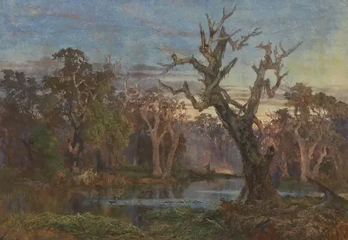
This painting is the only depiction we've found of the rich landscape before colonisation, including River Red Gum canopy.
"Lagoon in the Carrum Carrum Swamp – evening” James Curtis c.1872. Image courtesy of National Gallery of Australia


Farming History
The 50-acre (20.8 hectare) Down’s Estate property is located on Old Wells Road, Seaford, and adjacent to the internationally significant Ramsar-listed Seaford Wetlands.
Locally referred to as Down’s Farm, it is the last public farmscape in Seaford and designated as a Green Wedge planning zone and Urban Floodway. Previously owned by renowned whip and saddle maker, Harry Down, it retains only a few structures from its farming history and holds an important place in Seaford’s settler history. Both the large storage shed, and the farmhouse built around the 1950’s, as well as the concrete water tanks are all well-known local landmarks.
The buildings and land are part of the cultural heritage of the area, forming the backdrop to a part of Seaford/Frankston’s history after the subdivision of the land in 1919.
Pictured: The land since farming ceased, looking eastwards.
Frankston City Council Purchase of Site
Frankston City Council (FCC) moved to purchase the 20.8 hectares of land in the early 1990s after significant encouragement from the local community. The acquisition was finalised in 2006 at a cost of $1.25 million.
In 2011, a tender from FCC was called to establish a vision and recommendations for use of the site, leading to a series of community consultations being held in 2011 and 2012. The community response suggested that the site could accommodate the following considerations in any proposed site activation:
-
The site needs to act as a buffer zone for the wetlands and any activities on the site must not compromise the wetlands in any way.
-
The site would contribute to food security for the local communities of Frankston and neighbouring communities through food growing, distribution and community education relating to food production, including the production of Indigenous foods.
-
The site would be activated in genuine collaboration with the community, with activities to evolve over time and eventually become a thriving community based social enterprise with a range of options including education and job opportunities.
-
The management of Down’s Estate would be considered in relation to the wetlands as a “whole of site” package (both wetlands and Down’s Estate) that could align in ecological management, community education and ecotourism.


Formation of the Down's Estate Community Project
In January 2014, a group of passionate local residents formed Down's Estate Community Working Group to create an exciting and sustainable community project for Down's Estate.
After working with Council Officers during 2016, DECWG incorporated as Down's Estate Community Project (DECP).
Shortly after incorporation, DECP won second place in Think Big Frankston, a community voting initiative run by the FCC to inform its 2017-2021 Council Plan with the ten ideas to shape the themes and priorities for long term “Community Outcomes, a Planned City and Liveable City”.
DECP was granted a licence from FCC in 2017 for approximately 4 hectares of the original farm site on the east side of the shared user path, whereby we commenced producing food on site for the community, in alignment with the priorities in Frankston City Council Plan 2017-2021 (p. 12).
